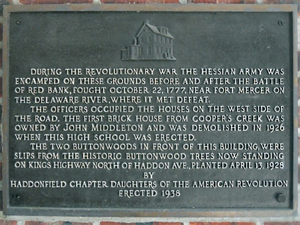
Hessian Encampment Marker
Haddonfield Memorial High School
King’s Highway East
Map / Directions to the Hessian Encampment Marker
Map / Directions to all Haddonfield Revolutionary War Sites
During the Revolutionary War, British forces occupied Philadelphia from September 26, 1777 until June 18, 1778. It was during this time that the British sent Hessian troops under Colonel Carl von Donop from Philadelphia to attack Fort Mercer, an American Fort on the Delaware River in what is now National Park. (Hessians were German mercenary soldiers hired by the British to fight in the Revolutionary War.)
The Hessians crossed the Delaware River from Philadelphia into New Jersey on October 21, 1777, landing in Cooper’s Ferry (now Camden). They marched to Haddonfield, where they camped for the night. Officers took up quarters in houses on the west side of Kings Highway.
The following day, the Hessians marched to and attacked Fort Mercer, in what became known as the Battle of Red Bank. They were defeated, and made their retreat to Haddonfield, where they again camped for the night. The following morning they marched back to Cooper’s Ferry, from where they crossed the Delaware River back into Philadelphia. [7]
This plaque, which commemorates the location of Hessian encampments before and after the Battle of Red Bank, is located inside the breezeway in front of Haddonfield High School. [8]